Cycle route 5
 43,5km
 2h 40min
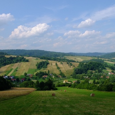
The route is quite easy, with three variants of decreasing high difference. The first one runs along the gravel and bitumen road. This long and strenuous with 200 metres altitude difference part of the route leads from Stefkowa to the 646 m a.s.l. pass. The second variant runs on the concrete slabs. It is a bit shorter, with the 150 meters altitude difference and it leads to the viewing glades over Serednica village. Finally, the third variant which runs along the asphalt road behind Brelików. It looks like a “little brother” of the first ones. It is easy to predict that there is a similar number of downhill runs, the first of which, gravel-concrete, leading to the ski station at the bottom of Laworta Mountain, is extremely exciting. Taking into account the viewing advantages, the stretch of the route that runs along agricultural used glades on the peaks of the Mostów massif is worth recommended. With no exaggeration, we can say that the glades are the imitation of the subalpine meadows (Połoniny). This 2-kilometre section is the only field trip. Thanks to the ridge run and insolation, the path quickly gets dry and the route is passable even after rainfalls. The trip connects three passes of the European watershed separating the San and Strwiąż rivers drainage basins. We start out from Olszanica to the east, towards Ustrzyki Dolne, we take no. 84 road which gently goes along the valley of the Stary Potok stream. We leave the road behind the Orthodox Church and then turn towards the forest massifs situated in the north of the village. We take the paved road along the Figura Stream. At the beginning it goes up gently between the fields, then steeply up to the narrow valley between the long massifs of Ostry Dział and Wielki Król. A wide, comfortable, quasi-asphalt road leads to the 646 m a.s.l. watershed dividing pass. In front of us there is the downhill part of the route on the north slope of Kamienna Laworta Mountain to the ski station at its foot and from here to the nearby village of Łodyna. We take direction to the northwest and without special effort we go up the local road through the resort village Dźwiniacz Dolny then we cross the watershed dividing Dźwiniacka Pass and reach the settlement Serednica. In front of us there is an interesting uphill part of the route along concrete road to the situated in the north of Serednica village ridge then taking the dirt road running along the ridge, we reach situated in the east the highest point of Mostów hill and go down down along the winding concrete road to the local road in the valley of the Uniaczka and Wańkówka streams. We reach it on the next watershed dividing pass of Wolanów. We turn to the west and go through the village of Leszczowate to nearby Brelików village. At its eastern end, we turn into a side road running through the forest in the small oil-rich valley hidden behind the small massif of Leśnianka. The road leads to the southern end of the village of Ropienka, where a bit of archaic oil field is still used. We direct now to the southwest. Taking the convenient local road, along the streams of Ropienka and Wańkówka, passing stretched on the distance of over 3 km Wańkowa, we go into Olszanica from the direction of settlement called Pod Magurą.
Route on the map
Modern tools to support the development of tourism for small tourist destinations in Poland (commune Olszanica) and Slovakia (period Svidnik). Microprojekt no .: INT/EK/KAR/1/I/A/0007